Conejo Open Space Foundation
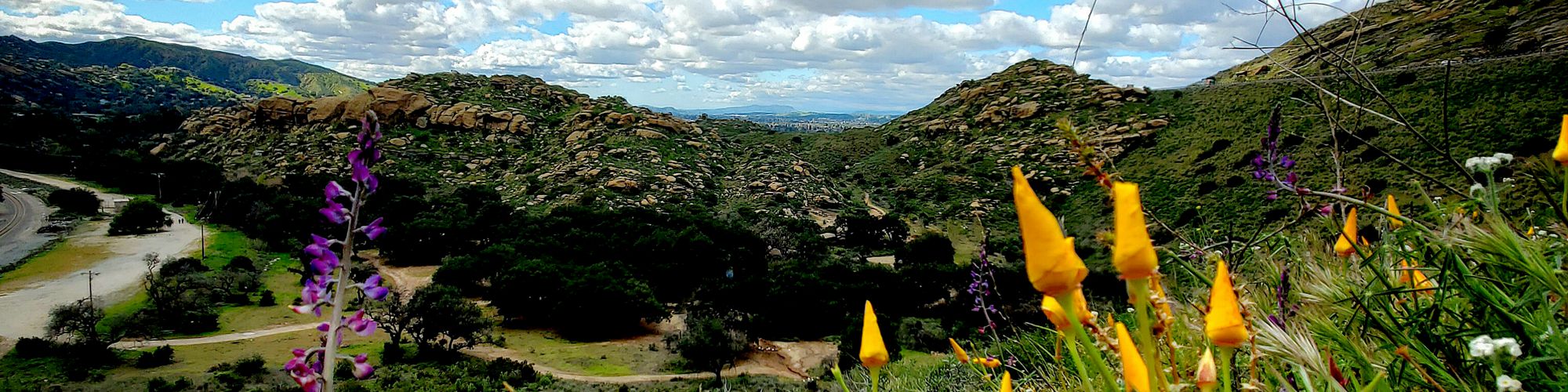
The Conejo Open Space Foundation is dedicated to helping preserve, promote and protect natural open space through community education and involvement. We support these efforts by fundraising and volunteer engagement.
Connecting community and nature for more than 30 years!


Upcoming Events
 Join us for “Living with Rattlesnakes: What Ventura County Residents Need to Know,” an in-person presentation on June 3 (5/13/2026) - Rattlesnake encounters are on the rise this spring, raising questions and concerns for hikers, homeowners, pet owners, and anyone spending time outdoors. On June 3, at 7:00 p.m., join wildlife educator Dana Stangel of Teranga Ranch and rattlesnake relocator John Noble in person for an informative community presentation. The event will be held at CRPD headquarters, 403 W. Hillcrest Drive, Thousand Oaks, CA 91360. Topics will include: Why encounters may be increasing this year What to do if you see a rattlesnake How to reduce attractants around your home Safety tips for hikers, families, and pets Common myths and misconceptions The… (read more...)
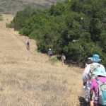 The 2026 Conejo Open Space Challenge Ends May 31! (2/2/2026) - Here's your chance to explore some of the best trails in the Conejo Open Space that many people are not familiar with! From March 1st through May 31st the Conejo Open Space Conservation Agency (COSCA) is challenging mountain bikers, hikers, trail runners and equestrians of all ages to try out some trails that may be new to them. See if you can complete all ten trails! If you do, you will be entered into a raffle and could win a prize donated by some awesome sponsors. View updates to the Challenge activities on the Challenge web page, including galleries of… (read more...)
News from COSF (View all the updates.)
The 2026 Conejo Open Space Challenge Ends May 31! (2/2/2026) - Here's your chance to explore some of the best trails in the Conejo Open Space that many people are not familiar with! From March 1st through May 31st the Conejo Open Space Conservation Agency (COSCA) is challenging mountain bikers, hikers, trail runners and equestrians of all ages to try out some trails that may be new to them. See if you can complete all ten trails! If you do, you will be entered into a raffle and could win a prize donated by some awesome sponsors. View updates to the Challenge activities on the Challenge web page, including galleries of… (read more...)
News from COSF (View all the updates.)
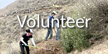
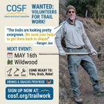 COSCA May Trail Work Day will be May 16 in Wildwood! (5/13/2026) - The Conejo Open Space Conservation Agency (COSCA) May trail work day, with support from COSF, will take place in Wildwood Park on the Eagle Point Trail on Saturday, May 16. According to Ranger Joe, it's really overgrown and will take a lot of work to fix it up. The improvement will be really satisfying to all the volunteers who help out!… (read more...)
 Two students from Westlake High School win COSF 2026 Eco Scholarships (4/23/2026) - Two local seniors, Anna Bronk and Tyler Limcaco, both from Westlake High School, are the recipients of the sixth annual Conejo Open Space Foundation scholarships. The $1,500 scholarships support students pursuing environmental-studies-related majors at two- or four-year colleges or universities. The scholarships, which provide up to $6,000 per student in total, are determined by a six-person panel. Anna Bronk, who is headed… (read more...)
 2026 Spring COSF Newsletter (4/12/2026) - The spring edition of the Conejo Open Space Foundation newsletter has been posted. In this edition… Annual Trails Education Days for 4th graders : "Forest Bathing and Healing" speaker event recording available : Bees of the Conejo Valley census : Spotlight on Dorothy Sullivan, COSCA Board Member and open space volunteer : Climate Crisis speaker event : Open Space Appreciation… (read more...)
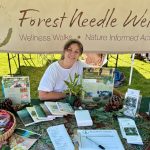 Irene Rowland explores why immersion in nature is essential to our mental and physical wellbeing—see her recorded presentation. (3/9/2026) - Irene Rowland, certified forest therapy guide and founder of Forest Needle Wellness, advised attendees to literally hug a tree during her March 4 presentation “Forest Bathing and Healing Landscapes: A Guide to Mindful Nature Connection.” Scroll to the bottom of this page to view the recording of her presentation. An expert in the Japanese practice of shinrin-yoku—"forest bathing”—Rowland explains that the… (read more...)
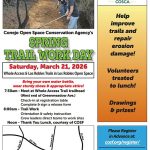 The Annual Conejo Spring Trail Work Day will be March 21 on the Whole Access Trail (3/4/2026) - Come out to help fix up our amazing trails on Saturday, March 21, when the Conejo Open Space Conservation Agency rangers will host the Annual Spring Trail Work Day! The work will be on the Whole Access and Los Robles Trails. The thank-you lunch and gift give-away for volunteers at noon are courtesy of COSF. Please register online so we… (read more...)
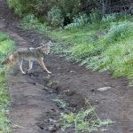 Winter ‘Four Seasons’ photo contest winner is David Filgas! (2/28/2026) - For our Spring 'Four Seasons' contest the challenge subject is sunlight beaming through Conejo Valley trees. Deadline for entry is May 31, 2026. If you would like to enter future contests, here are the rules: Every season, we’ll identify a specific phenomenon or item (e.g., “an oak tree”) for you to find within the Conejo Open Space. As long as… (read more...)
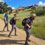
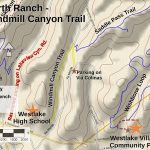 It’s New Map Monday: Windmill Canyon Trail in North Ranch (1/19/2026) - Highlights This easy route of only 1.6 miles with about 200' of climbing is very pretty, meandering through grassy meadows and groves of oak trees. Windmill Canyon Trail is one of the segments of the 2026 Conejo Open Space Challenge (https://cosf.org/challenge) Description This is a really easy and pretty hike, suitable for beginners. There is no street parking at the… (read more...)
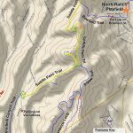 It’s New Map Monday: Saddle Pass Trail in North Ranch (1/12/2026) - Highlights Because of the amount of climbing, this is a more difficult trail, but there will almost always be a great view. There are two side trails along the way to get you to overlooks that have even better views than the main trail./ Saddle Pass Trail is one of the segments of the 2026 Conejo Open Space Challenge (https://cosf.org/challenge).… (read more...)
Join us for “Living with Rattlesnakes: What Ventura County Residents Need to Know,” an in-person presentation on June 3 (5/13/2026) - Rattlesnake encounters are on the rise this spring, raising questions and concerns for hikers, homeowners, pet owners, and anyone spending time outdoors. On June 3, at 7:00 p.m., join wildlife educator Dana Stangel of Teranga Ranch and rattlesnake relocator John Noble in person for an informative community presentation. The event will be held at CRPD headquarters, 403 W. Hillcrest Drive, Thousand Oaks, CA 91360. Topics will include: Why encounters may be increasing this year What to do if you see a rattlesnake How to reduce attractants around your home Safety tips for hikers, families, and pets Common myths and misconceptions The… (read more...) The 2026 Conejo Open Space Challenge Ends May 31! (2/2/2026) - Here's your chance to explore some of the best trails in the Conejo Open Space that many people are not familiar with! From March 1st through May 31st the Conejo Open Space Conservation Agency (COSCA) is challenging mountain bikers, hikers, trail runners and equestrians of all ages to try out some trails that may be new to them. See if you can complete all ten trails! If you do, you will be entered into a raffle and could win a prize donated by some awesome sponsors. View updates to the Challenge activities on the Challenge web page, including galleries of… (read more...) COSCA May Trail Work Day will be May 16 in Wildwood! (5/13/2026) - The Conejo Open Space Conservation Agency (COSCA) May trail work day, with support from COSF, will take place in Wildwood Park on the Eagle Point Trail on Saturday, May 16. According to Ranger Joe, it's really overgrown and will take a lot of work to fix it up. The improvement will be really satisfying to all the volunteers who help out!… (read more...) Two students from Westlake High School win COSF 2026 Eco Scholarships (4/23/2026) - Two local seniors, Anna Bronk and Tyler Limcaco, both from Westlake High School, are the recipients of the sixth annual Conejo Open Space Foundation scholarships. The $1,500 scholarships support students pursuing environmental-studies-related majors at two- or four-year colleges or universities. The scholarships, which provide up to $6,000 per student in total, are determined by a six-person panel. Anna Bronk, who is headed… (read more...) 2026 Spring COSF Newsletter (4/12/2026) - The spring edition of the Conejo Open Space Foundation newsletter has been posted. In this edition… Annual Trails Education Days for 4th graders : "Forest Bathing and Healing" speaker event recording available : Bees of the Conejo Valley census : Spotlight on Dorothy Sullivan, COSCA Board Member and open space volunteer : Climate Crisis speaker event : Open Space Appreciation… (read more...) Irene Rowland explores why immersion in nature is essential to our mental and physical wellbeing—see her recorded presentation. (3/9/2026) - Irene Rowland, certified forest therapy guide and founder of Forest Needle Wellness, advised attendees to literally hug a tree during her March 4 presentation “Forest Bathing and Healing Landscapes: A Guide to Mindful Nature Connection.” Scroll to the bottom of this page to view the recording of her presentation. An expert in the Japanese practice of shinrin-yoku—"forest bathing”—Rowland explains that the… (read more...) The Annual Conejo Spring Trail Work Day will be March 21 on the Whole Access Trail (3/4/2026) - Come out to help fix up our amazing trails on Saturday, March 21, when the Conejo Open Space Conservation Agency rangers will host the Annual Spring Trail Work Day! The work will be on the Whole Access and Los Robles Trails. The thank-you lunch and gift give-away for volunteers at noon are courtesy of COSF. Please register online so we… (read more...) Winter ‘Four Seasons’ photo contest winner is David Filgas! (2/28/2026) - For our Spring 'Four Seasons' contest the challenge subject is sunlight beaming through Conejo Valley trees. Deadline for entry is May 31, 2026. If you would like to enter future contests, here are the rules: Every season, we’ll identify a specific phenomenon or item (e.g., “an oak tree”) for you to find within the Conejo Open Space. As long as… (read more...) It’s New Map Monday: Windmill Canyon Trail in North Ranch (1/19/2026) - Highlights This easy route of only 1.6 miles with about 200' of climbing is very pretty, meandering through grassy meadows and groves of oak trees. Windmill Canyon Trail is one of the segments of the 2026 Conejo Open Space Challenge (https://cosf.org/challenge) Description This is a really easy and pretty hike, suitable for beginners. There is no street parking at the… (read more...) It’s New Map Monday: Saddle Pass Trail in North Ranch (1/12/2026) - Highlights Because of the amount of climbing, this is a more difficult trail, but there will almost always be a great view. There are two side trails along the way to get you to overlooks that have even better views than the main trail./ Saddle Pass Trail is one of the segments of the 2026 Conejo Open Space Challenge (https://cosf.org/challenge).… (read more...)Follow us on social media
 |
 |